
Physical Geography
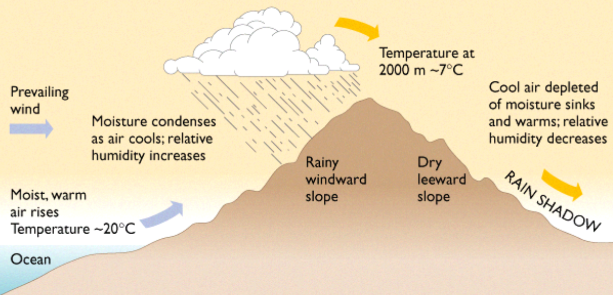 Click to learn more about Rain Shadow and the Orographic Effect
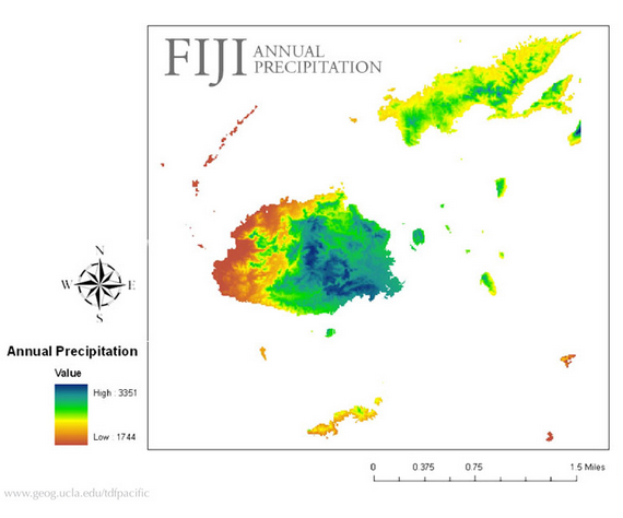
The Tropical dry forests of Fiji are located where the mountains create a rain shadow, on the leeward side of the mountain. The Fijian dry forest is one of the largest in the South Pacific region. The northwest part of the islands of Fiji is where the dry forests occur. This is due to the way that the mountain ranges on Fiji’s islands are oriented. This combined with the consistent southeast trade winds creates this rain shadow on the northwest side. The country of Fiji contains 300 islands and is located 3000 km east of Australia. Its exact latitudinal coordinates are 16-20 degrees South, and its exact longitudinal coordinates are 178 degrees east -178 degrees west. Viti Levu and Vanua Levu, which are two islands within the country of Fiji, occupy 78% of the land area. The bigger islands then result in most of the dry forest area. Furthermore, the elevation that these forests occur at is between 200 and 1000 meters above sea level.
This range of islands was mostly created due to volcanic activity, and these islands are now simply remnants of once active volcanos, with soils mostly made up of eroded volcanic rock. The youngest island, Taveuni, had a volcano erupt on it over 2000 years ago. The oldest landmasses have been exposed to biological activity for 5-20 million years.
This range of islands was mostly created due to volcanic activity, and these islands are now simply remnants of once active volcanos, with soils mostly made up of eroded volcanic rock. The youngest island, Taveuni, had a volcano erupt on it over 2000 years ago. The oldest landmasses have been exposed to biological activity for 5-20 million years.
http://www.naia.com.fj/cms/uploads/fiji/content/fiji-climate.gif
|
The Tropical dry forests of Fiji are located where the mountains create a rain shadow, on the leeward side of the mountain. The Fijian dry forest is one of the largest in the South Pacific region. The northwest part of the islands of Fiji is where the dry forests occur. This is due to the way that the mountain ranges on Fiji’s islands are oriented. This combined with the consistent southeast trade winds creates this rain shadow on the northwest side. The country of Fiji contains 300 islands and is located 3000 km east of Australia. Its exact latitudinal coordinates are 16-20 degrees South, and its exact longitudinal coordinates are 178 degrees east -178 degrees west. Viti Levu and Vanua Levu, which are two islands within the country of Fiji, occupy 78% of the land area. The bigger islands then result in most of the dry forest area. Furthermore, the elevation that these forests occur at is between 200 and 1000 meters above sea level.
This range of islands was mostly created due to volcanic activity, and these islands are now simply remnants of a once active volcano, with soils mostly made up of eroded volcanic particles. The youngest island, Taveuni, had a volcano erupt on it over 2000 years ago. The oldest landmasses have been exposed to biological activity for 5-20 million years. |
Climate and Natural Disaster
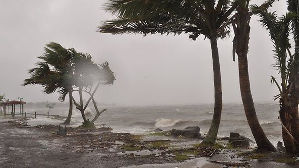 Tropical Cyclone Evan in Suva, Fiji (December 2012). Click image for article
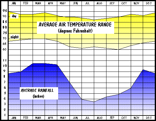
The dry forest of Fiji generally experiences long dry winters. The mean temperature of the forest in July is around 22 degrees Celsius, and around 28 degrees Celsius in January. So for the most part, the temperature in the forest is stabile and generally warm year-round. Rainfall varies between 1500-2250 millimeters per year, but is strongly seasonal. Most of the rainfall occurs between the months of December through April. This is then followed by drought-like conditions during the remainder of the year. During the dry season, the trees tend to drop all of their leaves, which aids in the conservation of water within the plant. This is also called a deciduous tree or forest. The average yearly wind speed that Fiji experiences is around 14 mph.
Cyclones are frequent between the months of November and April, but only hit the northwest side of the island directly. However, with deforestation and degradation seen in the forest areas all over the islands of Fiji, soil erosion on the coasts as well as on the mountainsides are being seen when big storms such as Cyclones come in. Furthermore, even though Cyclones directly hit the northwest side of the island, the Fijian dry forests are still affected by the storm, resulting in an increased amount of rainfall and wind speeds.
Cyclones are frequent between the months of November and April, but only hit the northwest side of the island directly. However, with deforestation and degradation seen in the forest areas all over the islands of Fiji, soil erosion on the coasts as well as on the mountainsides are being seen when big storms such as Cyclones come in. Furthermore, even though Cyclones directly hit the northwest side of the island, the Fijian dry forests are still affected by the storm, resulting in an increased amount of rainfall and wind speeds.
Sources:
- http://www.eoearth.org/article/Fiji_tropical_dry_forests
- http://worldwildlife.org/ecoregions/oc0201
- https://sites.google.com/site/tropicaldryforest47/
- http://www.eoearth.org/article/Fiji_tropical_dry_forests
- http://www1.broward.edu/~arodrigu/Environmental/Berg_Visualizing/biomes_summary.pdf
